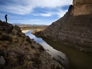
Santa Elena Canyon in Big Bend National Park
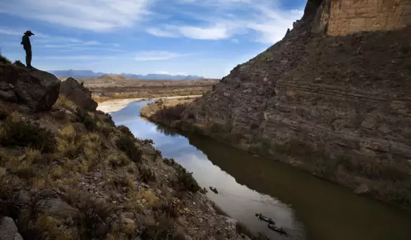
Santa Elena Canyon is one of the most popular landmarks on Big Bend National Park. Its steep walls rise close to each other about the low flow of the river Rio Grande which separates Mexico from the territory of the United States. Santa Elena Canyon was formed in southwestern Brewster County and is the largest within the park.
Santa Elena Canyon separates the limestone plateaus of Anguilla Mesa (Mesa de Anguila) on the north side of the river of the state of Sierra Ponce south of the country of Mexico. The length of the canyon is about seven miles, and its entrance is located about 7 miles southeast of the village towards Lajitas.
The mouth of Santa Elena Canyon is located six miles northwest of Castolon in the southeastern corner of Mesa de Anguilla. Castolon is the only place in the Big Bend, which holds historical depth. There are old farm and military buildings, but for most people it remains a place to stop for food and water before heading to Santa Elena Canyon.
Researchers stepped into the region of Santa Elena in the 17th and 18th centuries. There are huge uneven walls around the Rio Grande that reach up to 1500 feet. The fact that these walls are so close together enhances the magnificence of these views, and cannot help but make a person feel overwhelmed.
When one goes down into the foothills of the Santa Elena Canyon, one hears only the echoes of birds and people. Rio Grande River is, in some places during certain times of the year quite shallow and there is no problem passing through it, enabling you to explore the curious corners of the canyon.
For the tourist, the center of Big Bend National Park, St. Helena is located approximately 30 miles following the Ross Maxwell Scenic Drive. There is a specific route, which begins after the end of the road and that must be followed to reach the base of the canyon.
Rafting is a popular activity along the Rio Grande. Before reaching the Rio Grande, one has to cross through Terlingua Creek, a small pool, followed by a gradual decent. The entire route takes about 2 hours.