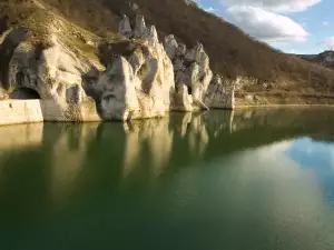
Pictured Rocks National Lakeshore
Natural phenomenon Pictured Rocks is one of the most beautiful places that you can see while walking along Lake Superior, which is the top and most significant in size among the Great Lakes.
These amazing rock formations are formed on the southern shore of Lake Superior. Pictured Rocks are known by the official name "Pictured Rocks National Lakeshore" and is most common in the Upper Peninsula of Michigan.
The Pictured Rocks spread over 67 km along the southern shore of Lake Superior and cover an area of 296 sq. km. The park offers visitors amazing views of the beautiful hilly coastline between the towns Munising and Grand Marais in Michigan. Natural phenomenon Pictured Rocks is an amazing blend of rock formations, natural rock arches, waterfalls and sand dunes.
The extremely beautiful Pictured Rocks have received their picturesque forms under the influence of natural forces - wind, ice and striking force of waves. Pictured Rocks are of sandstone and different colors due to the beautiful coloration of many minerals.
As a result, as the sun hits in different parts of the day, Pictured Rocks are stained with various shades of brown to reddish and its greenish color is due to iron, manganese, limonite and copper in lake water. By continuing impact, Pictured Rocks and their soft sandstone rocks are constantly changing.
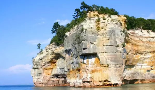
Imagination of man runs wild in view of the amazing rock coast of the southern shore of Lake Superior. Over time, natural forces have shaped these amazing formations so that one can easily recognize a fortress or castle.
Shapes among Pictured Rocks are Miner's Castle, Battleship Row, Indian Head, Lover's Leap, as well as many caves, like Color Caves, Rainbow Cave, Chapel Rock and many, many more. Due to rock falls Miner's Castle is entirely different since 13the April 2006. That is when it’s right tower fell into the lake Pictured Rocks.
The best way to see the incredible Pictured Rocks remains a boat on water. Places are built up with observational grounds, camping areas, hiking trails and beaches that allow visitors to reach the maximum number of observation positions.
The visitor center of the natural phenomenon gives all necessary directions and interpretations for the area. Visitors here have the opportunity to choose among the many hiking trails. Some are short and easy, others are longer and show more detail of the beauties of the local coastline.
The very name of Pictured Rocks comes from the 24-kilometer strip of colored sandstone cliffs, located northeast of Munising. The park was declared a protected area back in 1966, and annually on the southern shore of Lake Superior come between 400 000 to 500 000 visitors.
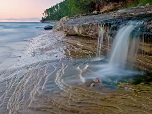
In the area can be seen many beautiful waterfalls that flow down the middle of the rocks and fall down to a beach or just into the lake. Among them are the Bridalveil Falls, Munising Falls, at 15 meters high, Miners Falls, Sable Falls, which in turn descends from a 23 meters height and a lot more other natural phenomena. Naturally occurring dunes, the Grand Sable Dunes in turn can be seen in the east end of Pictured Rocks.