Yukon River

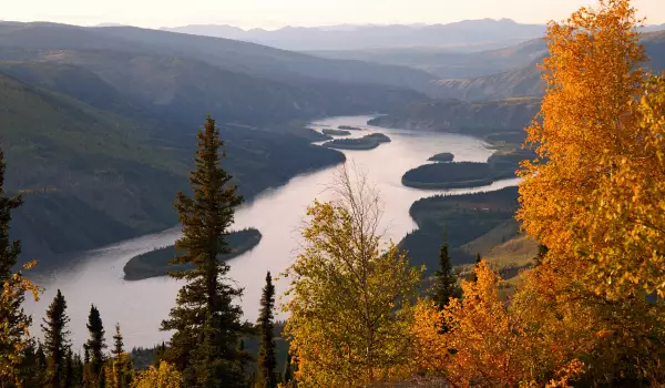
Yukon River is one of the largest rivers in North America. It is the largest, longest and greatest river in Alaska and near the Yukon - one of the northern territories of Canada, located in the north of the country, bordering Alaska. Most of her current passes through Alaska, but only a small part in the area, which shares the same name.
Yukon is the third largest river in North America. It stems from the merger of the rivers Lewes and Pelly in the southwest region of Yukon, and flows north of the coastal mountain range of northern British Columbia. Then Yukon River travels through the lands of the eponymous American territory, and Alaska, to reach and merge into the Bering Sea through its Delta. The total length of the Yukon River is estimated at 3185 km., 1149 km of which is in Canadian territory. Catchment drainage area of the Yukon is 840, 000 sq. km, of which 323, 800 square kilometers are in Canada.
Yukon River was one of the most used means of transport and shipping during Klondike Gold Rush, between the 1898-1899 years. Before building Klondike highway in the 50’s years of the 20th century, often river steamers were seen sailing.
Today, however, the Yukon River is not perceived in that way - not used for carrying passengers and goods, but rather as an integral part of the landscape of North America, which offers good conditions for fishing and some water sports.
Once, the Native North American tribes called Yukon, "big river" - that is the meaning of the name in the language Gwich'in. People who have spoken language Yup'ik even named Yukon River as Kuigpak.

Lewis River is actually the previous name of the upper reaches of the Yukon, from the initial source of the river - Marsh Lake, until it flows into the Pelly River, at Fort Selkirk. How exactly the river stems, is debatable. Some of Yukon springs from the Levelin Glacier, in the southern part of Lake Attlee in British Columbia. According to other posts, the River originates from Lake Lindeman in the northern Chilkutsk tracks.
Either way, Attlee Lake flows into Tagish Lake, and Lindemann Lake in Bennett Lake. Tagi empties into Lake Marsh, from the northern end of which leaves the Yukon River, just south of Whitehorse. Others, yet, think the start of the Yukon must be taken into Lake Teslin, Teslin River, the downstream of which is amplified when they reach the Yukon in Hutalinkua.
North of Whitehorse, Yukon River expands into Lake Laberge. Some other large lakes that are part of the river system of the Yukon are Kusawa Lake, Takhini River and Kluane Lake, River Kluan and then the White River. Klondike is the main tributary of the Yukon. It stems from Ogilvy mountains and flows into the Yukon River near Dawson.
Despite the great length of the Yukon, it is crossed by only four bridges, adapted for movement of vehicles. These are: bridge Lewis, north of Marsh Lake on the main Alaska route, Robert Campbell Bridge, which connects the suburbs of Whitehorse Riverdale with the center, the bridge Yukon in Carmacks on the Klondike Highway and the EL Patton Yukon River Bridge, north of Fairbanks, on the main Dalton Highway.
James Dalton Highway in Alaska, which crosses the Yukon River, is considered one of the most dangerous roads in the world. The over 650 km long highway is a road covered with gravel, directed to the north in arctic tundra. The road passes over Yukon River and is built to deliver supplies to oil facilities in the far north of Alaska. While traveling people are threatened not only by the surrounding snow and poor visibility, but also from frequent storms, during which passengers could be hit by flying stones. There are no nearby gas stations, or any stops.